Gonna skip to the oddest bit of trivia I picked up from this trip for Part 2, rather than talk nuclear weapons and atomic ephemera this time. We started with fun in Albuquerque for Part 1 and I’ll get back to fun at the Trinity Open House and the Titan Missile Museum next time for Part 3.

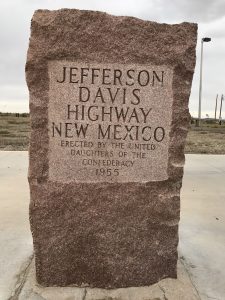
When we left Trinity Test Site, the long drive to Tuscon began. We made a pit stop in Truth or Consequences, NM for refreshments and to wave at the Virgin Galactic spaceport. On a more fictional level, we also waved to their neighbors, the new Tesladyne HQ. Of course, when you get refreshments this guarantees you will soon need to make use of a rest stop for a bathroom. And thus how we came to the Deming, NM rest stop on I-10, where My Lovely Assistant found this. When I came out of the bathroom, she instructed me to go read the marker and my jaw dropped. In disbelief, I asked a bit loudly “ARE WE ON THE EVIL TWIN OF THE LINCOLN HIGHWAY?!?”
The answer is yes, kinda. This is a relic of an early time in American auto culture history. Before interstates and before numbered routes (think Route 66 or US 1, 101, ) there were the Named Highway Auto Trails to try to map out long distance paths on the patchwork of dirt roads, railroad grades, and old wagon trails. The Lincoln Highway was the first transcontinental route, designated in 1913 and running from New York City to San Francisco. It is important to note that this wasn’t necessarily a paved transcontinental route, merely a marked path so you could know you were still going the right way, but this was way better than the previous nothing. We didn’t achieve a continuously paved long distance highway until Route 66 got that honor in 1938. The Lincoln Highway was a resounding success and spawned dozens of auto trails before they were superseded by the US Numbered Highway System in 1925.
Which is how the Jefferson Davis Memorial Highway (JDH) came to pass. The year after the Lincoln Highway was inaugurated, the United Daughters of the Confederacy (UDC) proposed a southern coast-to-coast route to honor the man they thought more than Lincoln’s equal. So, they started drawing up maps to pass through every state of the old Confederacy, the Davis plantation, and where he was captured. How could they do this? Before the Highway Act of 1925, all these auto trails were created, promoted, and maintained by organizations who had an interest in doing so, say because they’d like to help drive traffic near their tourist attraction, with government support (or at least tacit approval) usually at the state level. With state governments rather weak in this period and, especially in the South, with more or less no highway agencies, the UDC were free to promote whatever route they wanted, wherever and however they liked.
If you’re geographically inclined, you may notice this itch in the back of your mind which says that a route that goes where the UDC wanted and then goes out to the Pacific Coast is not what one might refer to as “direct”. When the Highway Act went through, there was a rush from all the auto trail organizations to get their pet trail formalized into one of numbered US Routes, which also would come with DOT money to improve those roads, increasing the amount of traffic they’d get. Unfortunately for the UDC, the JDH was such a hodge podge due to the conflicting interests of different UDC affiliated chapters that they had a hard time drawing a single continuous line to say where, exactly, their road went. They couldn’t even answer definitively if the highway’s eastern and western termini were Miami or Washington, DC for the Atlantic seaboard, or if it was San Diego or Seattle* for the Pacific seaboard. The DOT also couldn’t help but notice that a lot of the road segments the JDH overlapped with other auto trails.
And so, given the big thumbs down, the Jefferson Davis Memorial Highway as a transcontinental idea faded into memory, but many of the individual segments maintained that name scattered around the country and the UDC put up plaques to make sure people remembered. As I’ve oft said, once you name something and set a standard they are remarkably persistent through time. A lot of the old auto trail names still persist as local shibboleths where outsiders will call it the name their GPS says, but locals will call it by the name that’s been passed down for a few generations at this point.
To be fair, most of the old auto trails didn’t get outright turned into US Routes either. Even the Lincoln Highway, popular as it was at the time, got carved up into various US Routes and then interstates. It had a bit of resurgence in popularity after it’s 75th birthday and the Lincoln Highway Association resurrected in 1992. President Eisenhower’s absolutely miserable cross-country trek with an Army convoy as a young officer in 1919 was his inspiration for the modern interstate system on the basis of we CAN and WILL do better than that. In his case at least, a long road trip was very character, and infrastructure, building. By contrast, the JDH has no organized central organization caring for it and it depends on the interest and funding levels of the local UDC chapters. One might be inclined to draw some parallels to their respective namesakes…

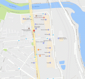
I was later informed by Test Subject Kristobek and Alexandra Petri that they either traveled on or looked out their office directly at the US Route 1 segment which runs right up to the Potomac Bridge, which if you look at Google Maps is quite clearly labeled as the Jefferson Davis Highway. Of all the pieces that have been ignored or sidelined this is the segment that’s perhaps the most traveled, improved, and retains its original name.
For those of you who live in the South and may feel like hunting down your local remnant of the old JDH, as a hint, go look for monuments to Confederate generals. If you’d like some help tracking things down, and to understand why My Lovely Assistant & I always read the plaques, well I have the website Read The Plaque for you. And, if you find one they don’t have, go upload it.
Also, don’t get tricked by the Jefferson Highway; that’s a totally different highway and Jefferson. [shakes an angry fist at New Orleans]
*: To explain how Seattle was a potential terminus of the southern transcontinental auto trail, this was to commemorate one of Davis’ last acts as Secretary of War prior the Civil War as he was responsible for commissioning surveys for wagon & train routes to Puget Sound. In 1939 the Washington State Legislature passed legislation to rename US 99 as the Jefferson Davis Highway in their state, making it the last segment of the JDH. Even though the auto trails were dead and gone at that point, the UDC were still quite keen to keep this going. When the Federal Aid Highway Act of 1956 was passed, we started retiring the US Routes but US 99 was popular enough that California, Oregon, and Washington all retained the number designation for their state highway.
Until May 2016 when they finally changed the name, if you were driving on WA-99, you were on the Jefferson Davis Highway, Seattlites.